

Sneckdowns: Should snowstorms plan your streets?
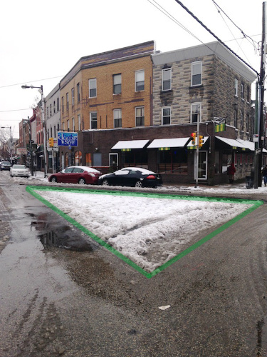
What could Philly build in the snow triangle? A tiny park? An island to make it safer and easier to cross the road? Sneckdown brought to you by the superb blog This Old City.
Throughout urban areas hit hard by wintry weather this season, Mother Nature is making her own traffic planning suggestions known. Piles of snow known as “sneckdowns” — more on the origin of that word later — are drifting into areas that, upon reflection, are ideal for road diets and sidewalk extensions. As Streetsblog reports, “all that snow piling up at intersections shows us the excess road space that could be reclaimed permanently to calm traffic.”
The rolls-right-off-your-tongue term “sneckdown” is a “portmanteau of ‘snow’ and ‘neckdown,’” reports the DC area blog, Greater Greater Washington, “the latter being another term for sidewalk curb extensions. So it literally means a sidewalk extension created by snow.” After being hit with multiple snowstorms this season, vehicles are on the road — and using much less space than they would otherwise.
search
Though a hashtag search for “sneckdowns” will today elicit hundreds of tweets and photos, the term first came into popularity back in 2006, when Streetfilms’ Clarence Eckerson, Jr. — who was frustrated by slow governmental response to traffic calming techniques in Brooklyn — published a video revealing how neckdowns (sidewalk curb extensions) are created during snowstorms when plows push snow to the curb and cars are forced to use only the space necessary.
After snowplows clear sections of streets following each snowstorm, cars are forced to make do with much less space, and sneckdowns show exactly where space might be budgeted, re-imagined, and re-purposed with new sidewalks or median — changes that can clearly be made without negatively affecting drivers. “The snow is almost like nature’s tracing paper,” Eckerson told the BBC. “When you dump some snow on this giant grid of streets, now you can see, visually, how people can better use the streets.”
Take East Passyunk Avenue, in South Philadelphia. The street is replete with triangular patches of snow, such as one that could potentially accommodate a “parklet,” as well as multiple areas ripe for sidewalk extension potential, reports local blog, This Old City. Then there’s Brooklyn’s Fourth Avenue, captured in this photo, and another example, in DC, seen here.
The concept of snow as a traffic-calming tool itself isn’t new; it can be found in a 2001 Transportation Alternatives’ magazine article: “The areas where snow remains untouched on the sides of streets shows where neckdowns could and should be installed. The remaining street space is all that cars and trucks need to negotiate the intersection.” And, as The Atlantic reports, director of the Walkable and Livable Communities Institute, Dan Burden, has been advocating snow traffic patterns as an engineering tool since the 1990s.
It’s a useful insight, but is anyone actually, well, using it? As Burden told The Atlantic, some Australian engineers have used cake flour and oil stains to discover similar information about traffic patterns. After the initial research, traffic cones would be placed where the flour/oil/snow lines were documented, in order to “see how motorists handle that.” Following analysis of those changes, urban planners would be able to institute long-lasting changes.
However, in the U.S., according to Burden, roads are often created based on existing protocol, not on analysis of how roads are actually used. “They don’t observe. They open their books,” Burden said of road designers. “And because they’re not observing, they become very bad designers.” Plus, after a road has been completed, there is little follow-up to determine how it might evolve based on changing pedestrian and driver needs over time. “It’s one of the saddest things,” Burden said. “What if a doctor just kept doing operations and never followed up to see if the patient survives? I don’t think you’d want to go to that doctor.”
Still, there’s hope that the concept will take off this season. At least one governmental transportation office, in Raleigh, NC, has voiced interest, tweeting out a call for photos of wasted intersection space throughout the city.
Find more sneckdown photos online, including: child-friendly corners, wasted space, pedestrian park safety, and potential pedestrian crossings.
Like this topic? Check out our related products:
-
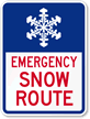
Snow Emergency Signs
-
Sidewalk Signs
Category: #Roadfix, Pedestrian safety, Resources, Road safety, Trends

